
Observation of Fair-Weather Cumuli Over Land Dynamical Factors Controlling Cloud Size and Cover
Submitter
Lamer, Katia — Brookhaven National Laboratory
Area of Research
Cloud Distributions/Characterizations
Journal Reference
Lamer K and P Kollias 2015. "Observations of fair-weather cumuli over land: Dynamical factors controlling cloud size and cover." 42(20), 10.1002/2015gl064534.
Science
This study combines a two-year record of state-of-the-art instruments such as the Ka ARM Zenith Radar (KAZR) for cloud thickness, Doppler lidar for clear and cloudy atmosphere vertical velocity, and Raman lidar for thermodynamics to produce a breakdown of hourly cloud cover into its active and forced cumulus components and treats each cloud-type separately. This separation is undertaken based on the hypothesis that these different cumuli types result from different sub-cloud layer processes and generate different cloud circulations.
Impact
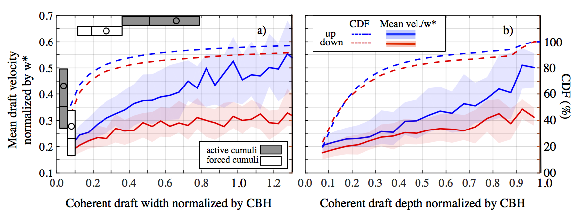
The nearly constant cumuli cover at SGP (12.5 percent) is created by an ensemble of active and forced clouds more frequently (58-56 percent) during early afternoon and less frequently (36 percent) during late afternoon when forced clouds tend to be the preferred mode of convection. Active shallow cumuli are both 2-3 times deeper and wider than their forced counterparts and exhibit stronger vertical velocity features with updrafts and downdrafts not in balance. These facts combined with our finding that wider sub-cloud layer clear-air coherent structures contain stronger updrafts further support the large-eddy simulation (LES) concept that larger updrafts experience less mixing and are more likely to penetrate the lifting condensation level and produce clouds (Zhu and Albrecht, 2003).
Very few sub-cloud layer dynamical parameters (e.g. updraft velocity, vertical velocity skewness) significantly differ when active clouds are the predominant mode of convection (active cloud cover greater than 5 percent). Ultimately it is the thermodynamic structure of the boundary layer that dictates the mode of convection: Larger (4-6 percent) mixed-layer averaged relative humidity and smaller (2K km-1) upper-level (300 m above cloud top) environmental stability are observed during active clouds periods (Zhang and Klein, 2013).
While the dynamic structure of the mixed-layer is very similar regardless of the presence or absence of active cumuli its characteristics vary according to cloud cover. Updraft fraction (Correlation coefficient: R 0.2) and updraft velocity (R 0.2) as well as vertical velocity skewness (R 0.3) and coherent updraft fraction (R 0.3) at the mixed-layer top significantly correlate to cloud cover and especially the portion attributed to active shallow cumulus clouds when they are present.
The latter two parameters are not currently considered in shallow cloudiness parameterizations. Moreover, these weak correlations suggest that the parameterization of shallow cumulus cloud is challenging. The inclusion of additional parameters could improve the prediction of fair weather cumuli properties, however, future studies are required to quantify their value.
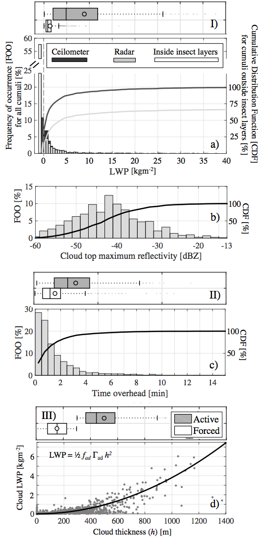
The current study also raises significant concerns about our ability to characterize the full fair weather cumuli population at the Southern Great Plains (SGP) site and its outcome will influence the final configuration of the SGP megasite, especially the placement of the ARM scanning cloud radars. While lidars can provide reliable sub-cloud and cloud base measurements, the same cannot be said for all microwave sensors. The liquid water path from the microwave radiometer is underestimated in 25 percent of the cumuli outside insect layers due to non-uniform beam filling. In addition, the presence of insects and the low radar reflectivity of cumuli pose a considerable detection challenge for the radar especially at the SGP—a continental site where droplet sizes are expected to be small and where insects are present near and above cloud base. Insects are biased air motion tracers and if misclassified for clouds can create cloud thickness bias. We determined that only 25 percent of the clouds detected by the ceilometer can be properly sized by the KAZR.
Summary
All these complications suggest that continental observation and model output inter-comparisons would require careful conditional sampling using instrument forward models. Moreover, these results suggest that cloud radars, when targeting fair weather clouds, should focus on cloud scale (3-6 km range) rather than mesoscale (10-25 km range) observations in order to avoid sensitivity related issues. Nevertheless, the statistics provided in this study provide robust observational targets for continental shallow convection modeling studies.Follow Us:


Keep up with the Atmospheric Observer
Updates on ARM news, events, and opportunities delivered to your inbox
ARM User Profile
ARM welcomes users from all institutions and nations. A free ARM user account is needed to access ARM data.